Showing 59 items matching pine creek
-
 Federation University Historical Collection
Booklet, Bulletin of the Northern Territory: Progress Report on the Gelogical Survey of the Pine Creek District, Northern Territory, 1914, 02/1914
... Gelogical Survey of the Pine Creek District, Northern Territory...Pine Creek... on the Gelogical Survey of the Pine Creek District, Northern Territory ...northern territory, mining, mining act, pine creek, patrick mcmahon glynn -
 Eltham District Historical Society Inc
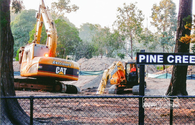
Photograph, Pine Creek, Diamond Valley Railway
... Pine Creek, Diamond Valley Railway...pine creek... melbourne Photograph Pine Creek, Diamond Valley Railway Colour ...Colour photographpine creek -
 Ballarat Heritage Services
Photograph - Colour, Clare Gervasoni, 'Pine View' Yandoit Creek, 2016, 16/01/2016
... 'Pine View' Yandoit Creek, 2016...Colour photographs of Pine View, Yandoit Creek.... Office goldfields Photograph - Colour 'Pine View' Yandoit Creek ...Pine View was the family home of Giovanni (John) Gervasoni and his family. It was passed to John's youngest son, Vincent Michael Gervasoni. Colour photographs of Pine View, Yandoit Creek. -
Bass Coast Shire Council - Art Collection
Artwork, other - Cypress Pine, Archies Creek, Matthew Petrucci
... Cypress Pine, Archies Creek... Wonthaggi Cypress Pine, Archies Creek Artwork, other Matthew ...AustraliaOil on canvasSigned -
 Federation University Historical Collection
Booklet, Northern Territory ... The Tanami Gold Country with Plans, 1909
... pine creek... from Pine Creel to Sturt's Creek by H.Y. L. brown; geological...pine creek sturt's creek tanami northern territory tanami ...Pink foolscap report of 12 pages, includes geological map from Pine Creel to Sturt's Creek by H.Y. L. brown; geological map between Mucka and Gordon Downs Station and Tanami by W.R. Murray; geological map of Tanami and surrounding country by W.R. Murray, and Plan of Lawne's Gold Prospecting Claim at Tanami by W.R. Murray pine creek, sturt's creek, tanami, northern territory, tanami gold country -
 Ballarat Heritage Services
Photograph - Colour, Pine View, Yandoit Creek, 2004, 26/06/2004
... Pine View, Yandoit Creek, 2004... Office goldfields Photograph - Colour Pine View, Yandoit Creek ...Colour photograph of Pine View, the home of Vince Gervasoni, of Yandoit Creek.yandoit creek, yandoit, pine view, vince gervasoni -
 Nillumbik Historical Society Incorporated
Photograph - Black & white photograph, "Pine Grove" Upper Diamond Creek
... "Pine Grove" Upper Diamond Creek... Photograph "Pine Grove" Upper Diamond Creek ... -
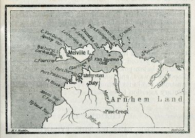 Ballarat Heritage Services
Map, Melville Island
... pine creek... island bathurst island pine creek daly river ...Copy of a map from 'A Short History of Australia' by Ernest Scott.map, explorers, exploration, melville island, tiwi islands, arnhem land, palmerston, daly, croker island, bathurst island, pine creek, daly river -
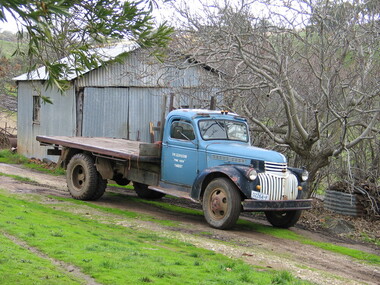 Victorian Interpretive Projects Inc.
Photograph - Colour, LJ Gervasoni, Vince Gervasoni's Truck, Yandoit Creek, 2004, 26/06/2004
... and Catherine Cugley of 'Pine View' Yandoit Creek. John Gervasoni's... at 'Pine View', Yandoit Creek. ... iron shed at 'Pine View', Yandoit Creek. Vincent Michael ...Vincent Michael Gervasoni was the son of John Gervasoni and Catherine Cugley of 'Pine View' Yandoit Creek. John Gervasoni's father, Luigi Gervasoni, was born at San Gallo, Bergamo, Lombardy, Italy. He was one of the earliest settlers at Yandoit Creek and contributed to the building of some of the drystone buildings.An old truck parked in front of a corrugated iron shed at 'Pine View', Yandoit Creek. yandoit, yandoit creek, gervasoni, vince gervasoni, luigi gervasoni, truck, pine view -
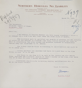 Federation University Historical Collection
Letter, Letter from Northern Hercules No Liability to the Ballarat School of Mines, 28/03/1957
... asking for a qualified assayer to work at the Pine Creek Gold... asking for a qualified assayer to work at the Pine Creek Gold ...Many mining companies sought staff from the Ballarat School of Mines.Typed letter on Northern Hercules No Liability letterhead asking for a qualified assayer to work at the Pine Creek Gold Mine 160 miles south of Darwin. The letter was responded to by R.W. Richards, Principal of the Ballarat School of Minesballarat school of mines, northern hurcules no liability, northern territory, mining, letterhead, r.w. richards, dick richards, mining companies, assayer -
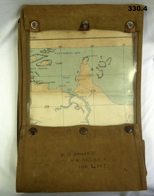 Bendigo Military Museum
Accessory - MAP CASE & MAPS, C.1939 -45
... Robinson Sydney .4) Map Pine Creek N.T...., New Guinea made by Hec Robinson Sydney .4) Map Pine Creek N.T ...John James Davies No VX35280 enlisted in the 2nd AIF on 1.8.40 age 31 years. At discharge on 30.11.45 he held the rank of WO 2nd class in 2/108th Aust Light Anti Aircraft detachment..1) Map case, canvas khaki. .2) Map of Darwin, NT. Scale 4 miles to 1 inch. .3) Map, folded, New Guinea made by Hec Robinson Sydney .4) Map Pine Creek N.T.zippered section marked "J. J. Davies VX35280 108 LAD”maps, canvas case, military -
 Ballarat Heritage Services
Photograph - Black and White, World War One Postcard from John Joseph Gervasoni
... Gervasoni (Cugley) of Pine View, Yandoit Creek.... John Joseph Gervasoni to Kate Gervasoni (Cugley) of Pine View ...World War One Postcard from John Joseph Gervasoni to Kate Gervasoni (Cugley) of Pine View, Yandoit Creek.yandoit creek, john joseph gervasoni, world war one, kate gervasoni, kate cugley -
Federation University Historical Collection
Book, C.E. Bristow, Government Printer, Northern Territory of South Australia Government Geologist's Reports on Recent Mineral Discoveries, 1908
... information on:- Pine Creek District; Brock's Creek, Anson Bay... geologist's Report including information on:- Pine Creek District ...Foolscap government geologist's Report including information on:- Pine Creek District; Brock's Creek, Anson Bay, Northern Territory Boring Operations Images Include: 'Mob of Blacks ad Tamarind Tree near Cliff Head, Anson Bay; Diamond Drill Boring Camp, near Cliff Head, Anson Bay, Wannomi Swamp; Daly River Crossing; Battery and Chinese Miners, Driffield Sketch Plan of the Mount Davis Copper FIeld, Sketch Plan Shewing POsition of Mineral Localities and Claims Near Wolfram Camp, Sketch PLan of the Pin Creek District Shewing Metalliferous Localities. h.y.l. brown, mining, boring, aborigines, aboriginal, chinese, south australia -
 Ballarat Heritage Services
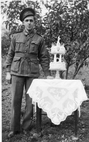
Photograph - Black and White, Vince Gervasoni and his 21st birthday cake
... Yandoit Creek farm 'Pine View'. ... of his famile's Yandoit Creek farm 'Pine View'. Vince ...Vince was the youngest son of John and Catherine Gervasoni, and the grandson of Luigi Gervasoni. Black and white photograph of Vince Gervasoni in World War 2 AIF uniform, standing next to his 2 tier 21st birthday cake. The photograph was taken in the back yard of his famile's Yandoit Creek farm 'Pine View'. yandoit creek, vince gervasoni, birthday cake, world war 2 -
 Eltham District Historical Society Inc
Photograph, Mr Yates, Clerk of the Course for the Diamond Creek Racing Club, c.1880
... . "Mr Yates of Pine Grove, Upper Diamond Creek was the local... of Diamond Valley 1979. "Mr Yates of Pine Grove, Upper Diamond Creek ...Photo from J. Sinclair reproduced on p92 of The Diamond Valley Story by Dianne H. Edwards, Shire of Diamond Valley 1979. "Mr Yates of Pine Grove, Upper Diamond Creek was the local postmaster, and Clerk of the Course for the Diamond Creek Racing Club in the 1880s. He is dressed for a meeting - the coat was scarlet. When racing ended at Diamond Creek in the 1890s he became Clerk of the Course at the Yarra Glen track."Black and white copy of photo printed on glossy photographic paper 30.5 x 40.5 cm (12 x 16 inch); image size approx. 18.5 x 28 cmclerk of the course, diamond creek racing club, diamond valley story, horse, mr yates, pine grove, postmaster, upper diamond creek -
 Federation University Historical Collection
Book, Final recommendations Ballarat Study Area Land Conservation Council, Victoria, 1982
Yellow soft covered report of 95 pages . The contents of the report include: Parks, reference areas, wildlife reserves, water production, harwood production, softwood production, flora Reserves and Flora and Fauna reserves, bushland reserves, historic area and reserves, rivers and streams, Roadside conservation and Highway parks, Education areas and School Plantations, Lake Reserves, geological reserves, recreation, scenic reserves, agriculture, mineral and stone production, utilities and survey, township land, Uncommitted Land, military training, other reserves and public land. Maps include: The Study area 1: 250 000 Supplementary Mapsland conservation authority, ballarat, endowment plantations, pine plantations, langi ghiran state park, mount buangor state park, enfield state park, ballarat-creswick regional park, rossbridge, black lake, flax mill swamp, dereel lagoon, lake bolac, lake wongan, langi ghiran reservoir, gong gong reservoir, pincotts reservoir, beales reservoir, wilsons reservoir, moorabool reservoir, korweinguboora, korweinguborra reservoir, learmonth bores, sago hill, illabarook reservoir, ballarat water commission, dunneworthy, mount cole, mont lonarch, ben major, waterloo, trawalla, linton, ross creek, canadian, shepherds flat, lal lal, mount doran, raglan, chute, carngham, buninyong, watsons hill, enfield, cape clear, illabrook, rokewood junction, mount warrenheip, nerrina, jubilee, golden stream, australasian deep lead mine, happy valley school, piggoreet, berringa, bulldog, ballarat common, wildlife, water, timber, flora, rivers, geology, agriculture, warrenheip -
 Bairnsdale RSL Sub-Branch Inc.
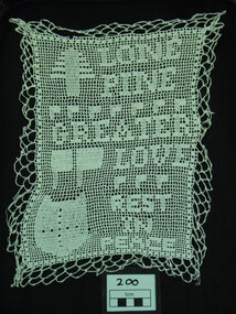
Momento Doily, Resident "Penderscourt", Early 20th Century
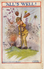
Hand •crochet cloth Doily, probably cotten, Dedication Inscription,Lone Pine Greater Love Lost rest in peace Pine tree, Flags / banners, Shield with cross, Embroided in the momento "LONE/PINE/GREATER/LOVE/REST/IN/PEACE".handcraft, lone pine, doily, hand crochet cloth doily, world war one handcraft, love token, momento anzac cove -
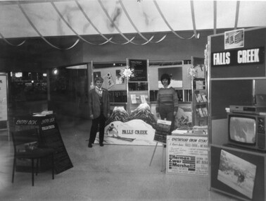 Kiewa Valley Historical Society
Photographs - Mt Beauty, Tawonga South and Falls Creek
Mt Beauty and Tawonga South are in the Kiewa Valley Mt Beauty and Tawonga are in the Kiewa Valley. Many of these photos record people who lived in these towns and their activities.Collection of black and white photos of Mt Beauty and Tawonga. Most are labelled (and some include names but no dates) in pencil on the back.Varying sizes. 1. Marketing Falls Creek 2. Driver Education Car Presentation- Mt Beauty Secondary College 3. Start of Mt Beauty Marathon 4. Mount Beauty Paramedical Day Care Centre 5. Falls Creek - Original Halley's Comet 6. Falls Creek - Original Snow-making on Twin Towers 7. Group of 10 girls 8. Mt Beauty Primary School - Tidy Towns Competition 9.Mt Beauty Primary School 10. Start of Mt Beauty Marathon 11. Lou Leiberman - Local Member 12. Bank Manager, Commonwealth Bank on left. 13. Driver Education Car - Mt Beauty Secondary College 14. Original Snow-making on Twin Towers at Falls Creek 15. Two girls 16. Mt Beauty - Home Improvement Centre 17. Tawonga District Hospital/Mt Beauty Hospital before the Nursing Home - removing pine trees 18. Water Board Installation at Tawonga South (outside Rookes house) 19. Dederang Catholic Church 20. Two men (names on back) 21. Tawonga Store 22. Mt Beauty - old butcher shop on right hand side 23.Tidy Towns Mt Beauty Labelled in pencil on the backmt beauty, tidy towns, driver education, marathon, falls creek -
 Eltham District Historical Society Inc
Photograph, Edendale Farm, Eltham Heritage Tour, 24 May 1992, 24/05/1992
ELTHAM HERITAGE TOUR The Society excursion on 24th May 1992 was arranged by David Bick, leader of the team carrying out the Shire's heritage study. David selected a number of sites or buildings identified in the study, some of them lesser known components of the Shire's heritage. The tour commenced at the Eltham Shire Office at 10.00 am. Travel was by private car and mini-bus with stops at about twelve locations for commentary by David.It included a short walk in Hurstbridge and lunch at Kinglake. Highlights of the tour included: - 10 am Leave from Shire Offices - 3 Important Trees - A Physical Link to Eltham's First Settlers - Toorak Mansion Gates - A Surviving Farm House - An Intact Circa 1900 Main Street - First Settlers - Gold Miners, and Timber-getters - An Early Hotel - A Pioneering Homestead - Changing Eltham Shire - 20th Century - 4 pm Afternoon Tea and Finish Tour Extract from ELTHAM CULTURAL HERITAGE TOUR (Newsletter No. 85, July 1992, by Bettina Woodburn) "The land was unprofitable for intensive farming, but there was always water in the Diamond Creek. The railway, a technological advance, followed the valley, and was provided to transport produce. At North Eltham we were privileged to tour a surviving farmhouse of the 1860-70 era at the Shire’s Edendale Farm, with the as yet unfinished Sculpture for a front fence - bulbous tree-trunks decorated with salt pots, with cross members from the old trestle bridge. As was usual these six veranda posted houses faced South (or East, away from the sun!) with the scullery, kitchen and pantry "out the back". The veranda, which must have been very narrow, no longer exists. It probably wrapped around three sides. The drive took us past the Dutch Windmill, only twenty years old and in the Shire of Diamond Valley, then the Diamond Creek Cemetery with impressive gateway, to a detour to see another old farmhouse, isolated on a hill off Murray Road Wattle Glen. Here was a particularly thick patch of exotic planting of pines and cypresses. Subsistence farming no longer pays. Following the rail-line we noticed on the left near Silvan Road an Edwardian cottage and on the right near Yates Road the old school residence for this Upper Diamond Creek area."Record of the Society's history and activities and highlighting various aspects of the Heritage Study undertaken by David Bick used to create the future heritage overlay for the Shire of Eltham and later Nillumbik Shire.Roll of 35mm colour negative film, 4 stripsKodak Gold 100 5095eltham, shire of eltham historical society, activities, heritage tour -
 Eltham District Historical Society Inc
Photograph, Monash Bridge, Arthurs Creek Road, Hurstbridge, Eltham Heritage Tour, 24 May 1992, 24/05/1992
ELTHAM HERITAGE TOUR The Society excursion on 24th May 1992 was arranged by David Bick, leader of the team carrying out the Shire's heritage study. David selected a number of sites or buildings identified in the study, some of them lesser known components of the Shire's heritage. The tour commenced at the Eltham Shire Office at 10.00 am. Travel was by private car and mini-bus with stops at about twelve locations for commentary by David.It included a short walk in Hurstbridge and lunch at Kinglake. Highlights of the tour included: - 10 am Leave from Shire Offices - 3 Important Trees - A Physical Link to Eltham's First Settlers - Toorak Mansion Gates - A Surviving Farm House - An Intact Circa 1900 Main Street - First Settlers - Gold Miners, and Timber-getters - An Early Hotel - A Pioneering Homestead - Changing Eltham Shire - 20th Century - 4 pm Afternoon Tea and Finish Tour Extract from ELTHAM CULTURAL HERITAGE TOUR (Newsletter No. 85, July 1992, by Bettina Woodburn) "On the Arthurs Creek Road is a bridge designed by Monash, which we admired before walking across the little park with a mud-brick and timber shelter, to the Hurst family graveyard. There are two marked graves, one, Henry who was shot by Burke the bushranger and a cairn has a plaque listing others buried here from 1866 onwards. Burke was captured and tied to the wheel of a dray under the eucalypt near the waterhose/standpipe. Close by the kindergarten, at this place are three trees on the National Trust Register, a Canary Island pine, a Canadian cedar and probably a spruce. Radiata pines and a thick bolled peppercorn surround the little cemetery. Continuing along Main Street we notice elm trees planted as a war memorial, then on the left a 1930 timber house, a 1910 store and residence, resplendent with wrought iron trim, a double fronted Hardware Store and cypresses on the back alignment of a new vacant block. On the right side of the street is a less interesting attempt at an 'in character' shop. Further on are more early homes, one tucked away at the rear with two tall palms by the front steps. Another curiosity is a rounded veranda corner and there are more galvanised iron sheds or garages, before a mud-brick Dentist's Surgery. Beyond the round-a-about is St Peters Church, of mud-brick construction shared by Catholic and Anglican parishioners, overlooking the river flood plain. Leaving Hurstbridge on the Kinglake Road, we ate our picnic lunch beside the communication tower and enjoyed views of Melbourne, Yan Yean Reservoir and the distant Dandenongs beyond the spreading suburbs. Next we drove to the North West boundary of the Shire at Masons Falls Road towards Whittlesea. On the way to the North East Boundary we passed St Peters, a yellow wooden Church with a Tudor Archway; built in the early 1920's in the style of the 1860's. From the Healesville-Kinglake road the rolling hills had European aspects, the hedged fields and chestnut trees. Then it was back down the Hurstbridge Road through 'Aussie' bush of towering gums, with bracken and scrubby understorey, the Kinglake National Park, before more open country with deciduous trees planted in line, and a creek lined with willows."Record of the Society's history and activities and highlighting various aspects of the Heritage Study undertaken by David Bick used to create the future heritage overlay for the Shire of Eltham and later Nillumbik Shire.Roll of 35mm colour negative film, 4 stripsKodak Gold 100 5095shire of eltham historical society, activities, heritage tour, hurstbridge, monash bridge, arthurs creek road -
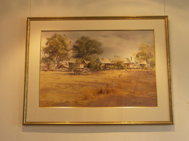 Friends of Westgarthtown
Painting, John Borrack, Last Days Ziebells "The Pines" Thomastown
Painted from the home (or front) paddock which ran south to the creek. The paddock was used for the cultivation of lucerne and maize crops in the lower regions while closer to the house where Ainwick Crescent is now situated, it was a burgeoning market garden for the cultivation of all varieties of vegetables. The large pines beyond, sheltered the farmyard on the west of Gardenia Road. That complex can be partly glimpsed on the left of the painting. This is a directly painted watercolour relying on the use of white paper and transparencies to impart a feeling of morning light. The figure is the artist's mother for whom the picture was painted. Provenance: Augusta Borrack (nee Ziebell) Collection, John Borrack CollectionWatercolour painting, depicting Ziebell's Farmhouse from the south (Thomastown and Mernda). Painting is mounted in a gold frame with cream board.Artist signature: John Borrack; Last Days at Ziebells "The Pines" Thomastown, 'Pro mea matre hanc picturan feci (In Memoria)'illustrations, watercolours, john borrack, ziebell, watercolour, painting -
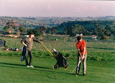 Hume City Civic Collection
Photograph, early 1980s
The series of photographs were taken shortly after the opening of the newly established Goona Warra Golf Club in the early 1980s. The golf club was part of the Goonawarra Housing Estate which was developed on the area previously known as Goonawarra Farm. The new golf club replaced 'The Pines' which was part of the Caloola complex.A coloured photograph of two golfers. One is preparing to hit off while the other is standing in the background with the golf buggy. They are standing overlooking the Goonawarra and Craiglea vineyards and the Jacksons Creek valley.goona warra golf club, george evans collection -
Whitehorse Historical Society Inc.
Article, Bring Back Our 286, 1/09/2014 12:00:00 AM
Residents are mounting pressure for Bus Route 286 from Box Hill to The Pines Shopping Centre to be re-instated.Residents are mounting pressure for Bus Route 286 from Box Hill to The Pines Shopping Centre to be re-instated.Residents are mounting pressure for Bus Route 286 from Box Hill to The Pines Shopping Centre to be re-instated.transport, bus services -
Whitehorse Historical Society Inc.
Article, Axe for pine trees, 1977
Article on the decision to remove many of the pine trees from Blackburn High School.Article on the decision to remove many of the pine trees from Blackburn High School.Article on the decision to remove many of the pine trees from Blackburn High School.springfield road, blackburn, blackburn high school -
Federation University Historical Collection
Book, Land COnservation Victoria, Land Conservation Council Victoria Report of the North Eastern Area (district 1), 1972
Yellow and brown soft covered book with brown tapespine. Includes land use, recreation, agriculture, apiculture, vegetation, birds, water physiography, geology, climate, soils, fauna, land systems. Block descriptions include Bethanga, granya, Lawson, Walwa,Pine Mountain, Mittamatite, Elliot, Bunroy, Wabba, Mount Cadgewa, ucyvale, Koetan, Burrowa. Black and white images include Mitta Mitta arm, Corryong, Tallangatta, Lake Hume, Aboriginal rock shelter at Mount Porcupine, Koetong uplands, Mitta Mitta massif, bandicoot, wombat, skink, Flaggy Creek plateau, Walwa, Murray Cod, Thowgla, emu, grasstree, land conservation, north-eastern victoria, environment, landuse, recreation, timber, apiculture, water, upper murray, vegetation, birds -
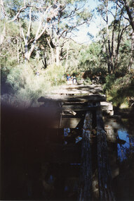 Halls Gap & Grampians Historical Society
Photograph - Coloured, C 1980s
This is a photo of one of the trestle bridges on the Heatherlie Quarry train line. The bridge is located near the current location of "The Pines" campground.The photo is a "front on" of a derelict trestle bridge crossing a shallow creek; many sleepers are missing and thick bush and trees surround the bridge. There are four adults at the end of the bridge, one standing and three seatede. The bottom left hand side of the photo is blurredstructures, bridges, quarrying, heatherlie -
 Halls Gap & Grampians Historical Society
Photograph - Coloured, C 1980s
This is a photo of one of the trestle bridges on the Heatherlie Quarry train line. It is located near the current site of "the Pines" campground.Photo shows an angle a derelict bridge with many sleepers missing. Thick bush and trees on left side with weeds in the front. The bridge is over a shallow creek. At the far end of the bridge a man wearing a pink cap and blue jumper stands looking towards camera. Three adults are seated and partly out of picture.structures, bridges, quarrying, heatherlie -
 Halls Gap & Grampians Historical Society
Photograph - Coloured, C 1980s
This is a photo of one of the trestle bridges on the Heatherlie Quarry train line. It is located near the current site of "the Pines" campground. The woman on the bridge is Janet Witham.Photo is of a derelict trestle bridge over a shallow creek, taken on an angle. There are many sleepers missing and the bridge is surrounded by thick bush and trees. There is bracken in the left foreground. A woman wearing a blue top and grey/brown slacks.structures, bridges, quarrying, heatherlie -
 Eltham District Historical Society Inc
Register, Register of Significant Trees, Shire of Eltham, 1993, 1993c
In 1983, the National Trust advised the Shire of Eltham that it was investigating a number of trees within the shire which had been nominated for recording the Register of Significant Trees of Victoria. The trees involved were described in the Shire of Eltham Historical Society Newsletter No. 29, March 1983 as follows:- 1. Eucalyptus melliadora (Yellow box) . a) An outstanding mature specimen 42 metres high in Laughing Waters Road, Eltham. b) Another mature specimen in Arthurs Creek road, Hurstbridge is reported to be the tree under which the bushranger Robert Bourke was tied after he shot and killed Henry Hurst in 1866 . 2. Quercus robur (English Oak). a) "Donaldson's Oak", Donaldsons Road, Kangaroo Ground was planted by John Donaldson from seed collected from Windsor Great Park in 1878. b) "Wippells Oak". This now misshapen tree is located on the St. Andrews Road near the Kangaroo Ground Fire Station. Its origins may have been similar to Donaldson's Oak, and as a young tree it apparently slipped from higher up the hill during wet weather. Both oaks are of local historical importance. 3. Eucalyptus globulus (Blue Gum). A large mature specimen at the corner of the Kangaroo Ground-St. Andrews Road and Bakehouse Road, Panton Hill. 4. Plantanas acerifolia (Plane tree) A number of trees forming the Avenue of Honour to Eltham's First World War soldiers along Main Road between Dalton and Pitt Streets, Eltham. 5. Pinus canariensis (Canary Island Pine), Pinus pinea, (Stone pine) and Cedras altlantica, (Cedar) These trees are located at the Hurst family graves in the grounds of the Hurstbridge Pre-school Centre. In 1991 the Shire of Eltham introduced controls into its planning scheme to protect sites of architectural, historic or conservation interest and significant trees. The controls were approved by the Minister for Planning and Housing. As advised in the Shire of Eltham Historical Society Newsletter No. 78, May 1991, a planning permit is required to demolish or alter any listed building or to destroy, lop or remove any listed tree. Provision is made for comments to be obtained from the National Trust or Historic Buildings Council in considering any applications. The buildings and trees listed were: Buildings: 250 Bolton Street Eltham (former Walter Withers home) "Rosehill" - Bonds Road Lower Plenty St Andrews Church of England - St Andrews "Montsalvat" - Hillcrest Avenue Eltham St Margarets Church and former vicarage - Pitt Street Eltham Presbyterian Church - Kangaroo Ground Parks and Environment Office (former police quarters) Main Road Eltham Former Court House - Main Road Eltham "Shillinglaw Cottage" - Main Road Eltham "The Robins" - Kangaroo Ground Road Warrandyte Trees: "Donaldsons Oak" - Donaldsons Road Kangaroo Ground Yellow Box - Laughing Waters Road Eltham Yellow Box - Arthurs Creek Road Hurstbridge Wippells Oak - St Andrews Road Kanqaroo Road Pines and Cedar - Hurst family cemetery Greysharps Road Hurstbridge Yellow Box - Parsons Road Eltham A large Blue Gum at Panton Hill has been listed but has recently died (1991). In 1993 work by Council Parks and Environment staff and volunteers resulted in the preparation of a Significant Tree Register listing forty-one trees or groups of trees. According to Shire of Eltham Historical Society Newsletter No. 91, March 1993, a similar number remained to be assessed for inclusion in the register. There is a wide range of indigenous and planted trees on private and public land and extending through the Shire of Eltham from Lower Plenty to Kinglake. Most can be viewed from publicly accessible locations. The Significant Tree Register lists 41 trees or groups of trees throughout the Shire. It contains a wide range of naturally occurring and planted trees. They have been assessed according to eleven criteria including size, age, rarity, historical value and the like. The list includes large old Red Gums at Lower Plenty, historic Oaks at Kangaroo Ground and Mountain Ash at Kinglake. The register includes a set of slides showing each tree. Garry Bartlett of the Council's Parks and Environment Section and Faye Shepherd were extensively involved in establishment of the register (Newsletter No. 93, November 1993). In 1999 Niliumbik planners prepared an amendment to the Planning Scheme to provide protection for approximately 200 of the places listed in the heritage studies and also in the Significant Tree Register commenced by the Eltham Council (Eltham District Historical Society Newsletter No. 127, July 1999. In 2004, The Register of Significant Trees was presented to the Eltham District Historical Society by Nillumbik Shire Council as part of a wider collection of of its memorabilia of the former Eltham Shire Council (EDHS Newsletter No. 159, July 2004. Album of loose handmade paper sheets contained within a handmade slip cover constructed of handcrafted card with encapsulated flora material (flowers, vines, ferns) and tinted. Each page also contains an embedded/adhered fern leaf also tinted with lacqueur or similar, text as appropriate in ink by hand calligraphy. Each page also has a white protective sheet cut to size and adhered to back surface with sticky tape and folded over face of page. Pages variously have photographs and coloured masks adhered with a gum resin. Over time much of this resin has let go and photos/masks have been reattached using acid free archival safe adhesive. 15 pages 41 x 29 cm inclusive of 3 blank pages. Slip case 42 x 30 x 1 cm; face cover of slip case has broken off at left hand margin as insufficient depth/flexibility for contents.arthurs creek road, blue gum (eucalyptus globulus), canary island pine (pinus canariensis), couties road, donaldsons oak, donaldsons road, eltham, english oak (quercus robur), eucalyptus melliodora, graysharps road, hurst tree, hurstbridge, ironbark (eucalyptus tricarpa), ironbark hill, kangaroo ground, kangaroo ground-kinglake road, laughing waters road, panton hill hotel, panton hill, parsons road, significant trees register, sonia van bodegraven, sonjart, stone pine (pinus pinea). atlantic cedar (cedrus atlantica), wippells oak, yellow box gum (eucalyptus melliodora), yellow box gum -
 Eltham District Historical Society Inc
Photograph, Edendale Farm, Eltham Heritage Tour, 24 May 1992, 24/05/1992
ELTHAM HERITAGE TOUR The Society excursion on 24th May 1992 was arranged by David Bick, leader of the team carrying out the Shire's heritage study. David selected a number of sites or buildings identified in the study, some of them lesser known components of the Shire's heritage. The tour commenced at the Eltham Shire Office at 10.00 am. Travel was by private car and mini-bus with stops at about twelve locations for commentary by David.It included a short walk in Hurstbridge and lunch at Kinglake. Highlights of the tour included: - 10 am Leave from Shire Offices - 3 Important Trees - A Physical Link to Eltham's First Settlers - Toorak Mansion Gates - A Surviving Farm House - An Intact Circa 1900 Main Street - First Settlers - Gold Miners, and Timber-getters - An Early Hotel - A Pioneering Homestead - Changing Eltham Shire - 20th Century - 4 pm Afternoon Tea and Finish Tour Extract from ELTHAM CULTURAL HERITAGE TOUR (Newsletter No. 85, July 1992, by Bettina Woodburn) "The land was unprofitable for intensive farming, but there was always water in the Diamond Creek. The railway, a technological advance, followed the valley, and was provided to transport produce. At North Eltham we were privileged to tour a surviving farmhouse of the 1860-70 era at the Shire’s Edendale Farm, with the as yet unfinished Sculpture for a front fence - bulbous tree-trunks decorated with salt pots, with cross members from the old trestle bridge. As was usual these six veranda posted houses faced South (or East, away from the sun!) with the scullery, kitchen and pantry "out the back". The veranda, which must have been very narrow, no longer exists. It probably wrapped around three sides. The drive took us past the Dutch Windmill, only twenty years old and in the Shire of Diamond Valley, then the Diamond Creek Cemetery with impressive gateway, to a detour to see another old farmhouse, isolated on a hill off Murray Road Wattle Glen. Here was a particularly thick patch of exotic planting of pines and cypresses. Subsistence farming no longer pays. Following the rail-line we noticed on the left near Silvan Road an Edwardian cottage and on the right near Yates Road the old school residence for this Upper Diamond Creek area."Record of the Society's history and activities and highlighting various aspects of the Heritage Study undertaken by David Bick used to create the future heritage overlay for the Shire of Eltham and later Nillumbik Shire.Roll of 35mm colour negative film, 4 stripsKodak Gold 100 5095eltham, shire of eltham historical society, activities, heritage tour